

15 Years of Tahoe Treasures
Prior to opening the Tahoe City Bluestone Jewelry... Read Article
The Tahoe region is home to an extensive network of hiking trails that are beloved by locals and tourists at every age and level. Although these trails are great year-round, summer is when the mountains come to life. Wildflowers are in bloom, the smell of pine trees fills the air, and it’s warm enough to take a dip in the lake to cool off after a long day on the trail.
As someone who grew up hiking with my family in Tahoe during school breaks, it was hard to pick just five of my favorites. Below, you will find five hikes that I think are essential to exploring different parts of the Tahoe region. Each hike boasts stunning views and leaves options for more adventures after the hike is complete.
I hope you enjoy exploring these trails as much as I do. Happy hiking!
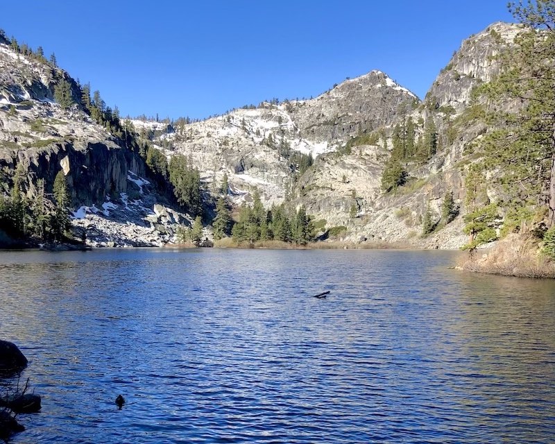
Photo: Eagle Lake and surrounding peaks in Tahoe's Desolation Wilderness
Miles: 1.8 Out and Back
Difficulty: Easy
Eagle Lake Trail is a fun hike for everyone and offers a variety of options for additional adventures. Located in Desolation Wilderness, Eagle Lake Trail offers a preview of the Tahoe backcountry and is sure to inspire wonder. At just under 2 miles, the hike is relatively quick. I highly recommend staying longer to swim in the lake, as it’s a great way to cool off on a hot summer’s day.
The trailhead is easily accessible by car and begins in Emerald Bay at the Eagle Falls Picnic Area. Make sure to get there early to secure a parking spot as this area sees some of the most traffic in the region. I always recommend getting there aound 5 or 6 in the morning to ensure my chances of getting a spot. You will need to fill out a permit at the trailhead.
If you want to add more miles, continue on the trail to the moderately challenging route to Velma Lakes and Maggie’s Peaks. Make sure you have a GPS for this one in case you veer off-trail.
You can also check out Eagle Falls, which can be accessed by crossing the road from your parking spot and continuing down to the beach to see Vikingsholm, the famed Scandinavian mansion, and Fannette Island. For the ultimate Emerald Bay adventure, enjoy a sunset picnic on the granite overlooks.
Miles: 2.5 Out and Back
Difficulty: Easy/Moderate
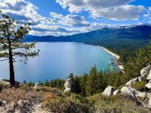
Monkey Rock has become quite the attraction over the past few years, and this increase in popularity has hikers and photographers flocking to this trail from all over the world. This trail is relatively quick and easy, making it fun for the whole family!
Located in Incline Village, the trailhead is easily accessible at the paid parking spots near the Tunnel Creek Cafe lot, which is also the starting point for the East Shore Trail.
It’s easy to follow as there are signs that point to the trail. You will start on a road behind the cafe and then follow the trail up a few long switchbacks to the viewpoint. It starts off mellow but does get a bit steeper as you continue up, so I recommend that you wear proper hiking boots. When you get to a fork in the trail, turn left and continue through the boulders and trees toward the lake. You will soon be rewarded with a postcard-worthy view of Crystal Bay!
Hint: The monkey can be a bit camera-shy, so I’ll help you find it! When you get to the lookout, look to your left (facing the lake). You will see a face on a rock that looks just like a monkey taking in the views.
If you want to extend your adventure, continue on the main path, which eventually becomes the Flume Trail. Here, you will gain more elevation and mileage to the Sand Harbor overlook and eventually Marlette Lake. Plan for a full day if you wish to attempt this hike and make sure to do the out-and-back route to get back to your car at the lot.
Tip: Make sure to use the day-permit parking lot and not the small parking lot for cafe customers. As with other popular trails, I highly recommend you get an early start to ensure you get a spot. Or, as an alternative, go about an hour before sunset. You will need to pay by the hour or get a full-day pass. I recommend getting a day pass and enjoying attractions in the area. There’s a lot to experience in Incline!
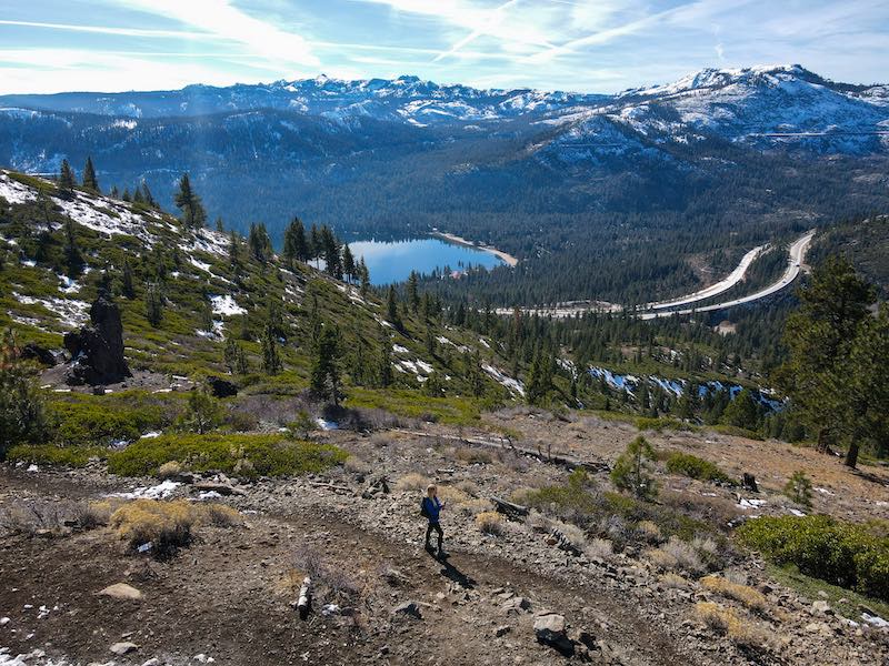
Photo: Drone view of Donner Lake nestled in the snow-capped peaks, seen from Glacier Way Trails
Miles: Around 4 Round Trip, Depends on the trail
Difficulty: Easy
Located just outside Truckee, the Glacier Way Trails offer adventures for all ages and abilities. It's one of my go-to year-round spots in the region, and I am so happy to share this trail with you. In the summer it comes to life, as wildflowers are abundant and bring vibrant colors to the trail. Make sure to bring your camera for this one!
Starting at the Glacier Way parking lot, this is an extremely popular trail for hikers, mountain bikers and trail runners. As the parking lot is small and in a residential area, I recommend arriving early to ensure you get a spot. There’s a network of trails here so you can create your own hiking adventure.
The most popular routes are the Johnson Canyon Overlook, Donner Lake Rim, Far Side Trail Loop and the Sunrise Bowl Loop. You can’t go wrong with any choice!
The views here are incredible. You can see Northstar California Resort, look down at Donner Lake, and get a panoramic view of the surrounding peaks.
After your hike, I recommend going down to cool off in Donner Lake and then going into Truckee to check out their vibrant restaurant scene.
Miles: Approx. 5 Miles Round Trip
Difficulty: Moderate
Located in the world-renowned Olympic Valley, the Shirley Canyon Trail has gained in popularity over the past few years. And for good reason! This hike is sure to pack a punch. With waterfalls, wildflowers, a lake and the option to hike to Palisades High Camp, this is an adventure you do not want to miss.
Due to the increase in popularity, you must park in the main Palisades parking lot and take a short walk to the trailhead (there will be markers pointing you in the right direction).
This trail does have some steep sections, so plan accordingly and hike with caution. Make sure to wear sturdy hiking boots with good tread and bring hiking poles if you feel like you could be unsteady. I also recommend having a GPS or AllTrails, as some parts can get a bit tricky to stay on the trail.
After you spend time at Shirley Lake, you have the option to continue hiking up to High Camp, where you will see incredible views of Lake Tahoe and the surrounding peaks. You will also have access to the Palisades amenities if you arrive within operating hours. Bonus points: You have the option to take the tram down from here for free!
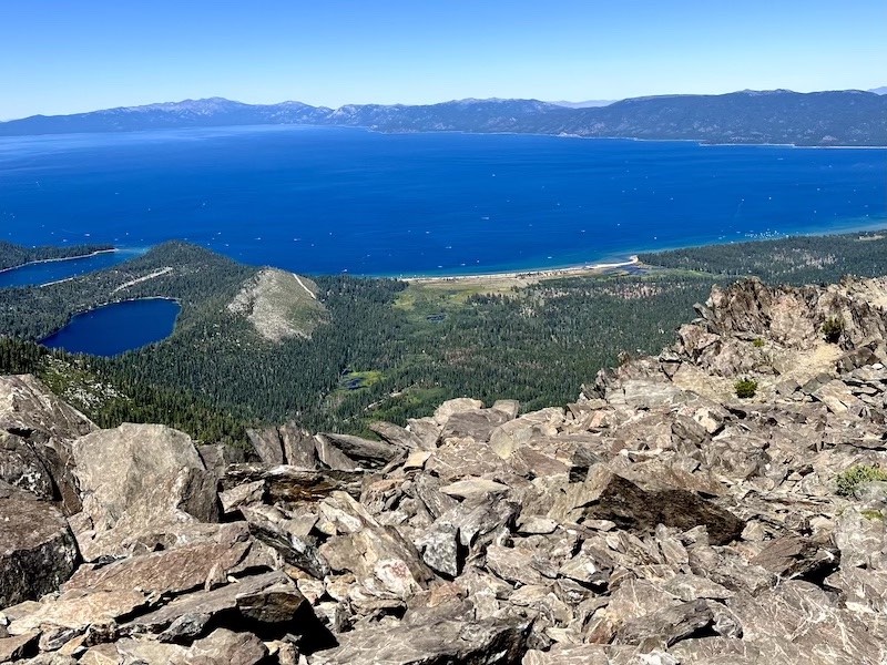
Photo: View of Lake Tahoe, Emerald Bay and Cascade Lake from the summit of Mount Tallac.
Miles: 9.6 Round Trip
Difficulty: Strenuous/Non-Technical
Mount Tallac is a Lake Tahoe icon offering some of the best views in the entire region. This hike is not for the fainthearted. Standing at an elevation of 9,739 feet, Tallac has an elevation gain of 3,284 feet, which can make for quite the workout!
I highly suggest starting this hike as early as you can. Parking can be limited, and there are very few shaded areas. Remember to get your wilderness permit at the trailhead, as that is required for day hikers as well as backpackers.
From the trailhead you will gradually make your ascent and reach an unparalleled view above Fallen Leaf Lake and South Lake Tahoe. As you continue, you will reach Floating Island Lake and Cathedral Lake. After Cathedral Lake the trail gets quite a bit steeper. Make sure to have poles just in case you feel unsteady!
As you continue your climb, the views of Lake Tahoe get better, but nothing comes close to what awaits you at the summit! You’ll be able to see a 360-degree view of Lake Tahoe, Emerald Lake, Fallen Leaf Lake, surrounding peaks and a variety of backcountry alpine lakes. Take some time to rest, eat your lunch and enjoy the views here – you will have earned it!
When you’re ready to go, head down the same way you came. Sometimes it can be a bit easy to get off the trail, so make sure you have a GPS or AllTrails and plenty of water.
After you’re done with the hike, I highly recommend going to nearby Fallen Leaf Lake for a swim. It’s great to cool off after a hot day of hiking and help with muscle recovery!
Plan accordingly. Summer in Tahoe sees a drastic increase in tourism, which means parking can be extremely limited. I always recommend starting as early as you can, especially on a longer or more technical hike.
Have a GPS or AllTrails app so you know where you are in case you get lost.
Bring enough water, food, layers, sunscreen and a headlamp in case you stay out later than expected. I always bring a small power bank too, just in case my phone levels get low.
Prepare for weather changes. As you are in the mountains, weather can take a turn unexpectedly; I’ve seen all four seasons on a summer hike! I highly recommend bringing a poncho, jacket and gloves just in case.
Be mindful of how you react to altitude. The mountains in the Tahoe Donner region can reach up to 10,000 feet, which can cause symptoms of minor altitude sickness. Stay hydrated, walk at a slower pace and descend if you feel too sick to move forward.
Bring a camera. There are so many stunning vantage points on these hikes as well as wildlife and wildflowers.
Leave no trace. Make sure to pack out everything you pack in. Some of these trails have garbage cans at the trailhead so you can place your trash there.
Don’t start campfires. Summer is wildfire season, and Tahoe is extremely susceptible to fires, which can get out of control quickly with high winds and dry heat. Please be mindful. There are plenty of hotels that have bonfire pits in the area, such as Station House Inn, Hotel Becket, Coachman and Basecamp.
Most importantly, have fun!
 Kirsten is an outdoor adventure enthusiast, writer and photographer. You can typically find her hiking, paddleboarding, cross-country skiing and checking out new spots to share in the Tahoe Donner region. She has been lucky to call Tahoe her second home since she was a child and aims to inspire people to experience Tahoe and fall in love with the beauty and adventurous spirit of the region through her blogs and content.


Tahoe Yacht Club • Homewood
Friday, August 7th 10:00 am
View All Events!
Grocery Outlet Incline Village
![]() Save BIG with great new deals every week!
See Incline Village's latest coupons here
Save BIG with great new deals every week!
See Incline Village's latest coupons here


